Lands
The OKIB Lands Department administers and manages OKIB tmxʷúlaʔxʷ (lands) under the Indian Act through participation in the Reserve Land and Environmental Management Program (RLEMP). This program supports First Nations in taking on greater responsibility for reserve land governance by carrying out land management authorities on behalf of Indigenous Services Canada (ISC).
The department oversees land transfers, Certificates of Possession, surveys, leasing, permits, rights-of-way, and land records, and assists Band members with land-related processes. To support these functions, the OKIB Lands Officer is appointed as a Commissioner for Taking Affidavits under the British Columbia Evidence Act, providing commissioning services for documents related to land transactions.
Our work ensures that the administration and stewardship of OKIB tmxʷúlaʔxʷ upholds Syilx values, complies with federal legislation, and supports the long-term interests of the community
UXO Settlement Information and Community Vote
IMPORTANT INFORMATION INTENDED FOR COMMUNITY MEMBERS ONLY
The Okanagan Indian Band is currently engaging with Members regarding a proposed settlement related to unexploded ordnance (UXO) on OKIB lands.
A Community Vote has been scheduled for March 28, 2026, and all voting-age Members have been sent information outlining the proposed settlement and the voting process.
To support informed participation, OKIB is hosting a series of Member-only information sessions throughout February and March. These sessions provide opportunities for Members to hear updates, ask questions, and receive clarification directly from OKIB leadership, legal counsel, and financial advisors.
Sessions will be held both in person at community venues and online by Zoom to ensure Members can participate in a way that works for them (To request a zoom link please contact the Lands Department at landsadmin@okanagan.org)
Information Session Dates
- Thursday, February 19 – 5:30 p.m.
(Online) Zoom
Informal Discussion Meeting
- Thursday, February 26 – 5:30 p.m.
Head of the Lake Hall (Vernon)
Formal Kick-Off Information Meeting
- Monday, March 2 – 4:00 p.m.
10150 Bottom Wood Lake Rd, Lake Country, BC
Duck Lake Membership Forum
- Thursday, March 5 – 5:30 p.m.
Head of the Lake Hall (Vernon)
Main Information Meeting (Legal and Financial Advisors Present)
- Thursday, March 12 – 12:00 p.m.
Head of the Lake Hall (Vernon)
Elders Luncheon
- Wednesday, March 18 – 12:00–1:30 p.m.
Online (Zoom)
Drop-in Information Session and Q&A
- Thursday, March 19 – Time to be confirmed
Head of the Lake Hall (Vernon)
Electoral Officer Drop-In (Advance Voting Assistance)
- Wednesday, March 25 – 5:30 p.m.
Head of the Lake Hall (Vernon)
Final Information Meeting
- Saturday, March 28 – Vote Day
Head of the Lake Hall (Vernon)
Community Vote and Count
Voting Opportunities Image
Voting Information
Voting will take place in person on March 28 at Head of the Lake Hall, and electronic voting will also be available in advance.
Questions and Contact
To ensure Members receive accurate and consistent information, all questions or requests for additional details should be directed to:
- UXOsettlementquestions@okanagan.org
- landsadmin@okanagan.org
OKIB encourages all eligible Members to review the materials provided, attend an information session, and participate in the Community Vote.
Visit Our Departmental Pages
Departmental Staff
(Photo of person)
A member of the Okanagan Indian Band. Employed with the Okanagan Indian Band Organization since 1998 as the Chief and Council’s Executive Assistant and transitioning to the Lands Department in 2015. As Interim Director of Lands, Sherry is responsible for overseeing the day-to-day operations as well as support the strategic planning for OKIB Reserve Lands. In addition, Sherry currently supports the Additions to Reserve, Specific Claims and Unexploded Ordnances processes.
250-542-3444 ext. 4011 sherry.louis@okanagan.org
Kristi has been an employee with OKIB since October 2023 (previously in Education). Kristi is responsible for assisting the Lands department with secretarial, clerical, and administrative support.
250-542-3444 ext. 4016 landsadmin@okanagan.org
(Photo of person)
A member of the Okanagan Indian Band. Randy has been employed with OKIB since May 27, 1991, and has held the Lands Supervisor position since 1995.
His position oversees the INAC Reserve Land and Environment Management Program for OKIB Reserve lands to ensure the registration of land transactions on the six Reserves of the Okanagan Indian Band. This includes Locatee transactions, Locatee lease proposals, Locatee survey projects, OKIB Council Designation process, OKIB Leases, Addition to Reserve process, OKIB Permits, and includes providing information to OKIB legal counsel on the OKIB Specific Claims.
Randy’s position works with other OKIB departments on various matters, these departments are: Territorial Stewardship Division; OKIB mapping Tech; Public Works and Housing; Finance. And other OKIB departments on specific land matters, e.g. legal descriptions; ownership.
250-542-3444 ext. 4010 randy.marchand@okanagan.org
(Photo of person)
A member of the Okanagan Indian Band. Brittany started as the OKIB Lands Administrative Assistant in July of 2015 and recently completed the Professional Lands Management Certification Program through the National Aboriginal Lands Manager Association to become a certified Lands Manager for the OKIB Lands department. Brittany is also a Commissioner for Taking Affidavits. Her role includes administering land and natural resource transactions and working with the Lands Supervisor on lands matters such as surveys and utility projects for on reserve lands.
250-542-3444 ext. 4009 brittany.caron@okanagan.org
(Photo of person)
Currently UXO Liaison for the OKIB, Don has been working full time with OKIB since 2012. Don is a certified UXO Tech 1. Prior to returning home to the Okanagan territory, Don resided in Calgary AB working in the Oil and Gas industry in the technology sector. He was also involved in Real Estate buying and renovating houses.
250-542-3444 ext. 4012 don.louis@okanagan.org
Resources
Recreational Water Sampling is conducted in accordance with Health Canada recreational water standards guidelines. These tests focused on E. coli levels, an important indicator of water safety. The maximum acceptable limit for E. coli in recreational water is less than 400 MPN/100 mL.
Komasket Park, Smitkens Beach and the Mudhole are included in the testing. If conditions change, updates will be shared immediately via newsletter, community postings, and social media.
Recreational Water Sampling for OKIB Beaches (Updated July 30th, 2025)
Purpose:
RLEMP supports the administration and stewardship of OKIB tmxʷúlaʔxʷ (lands) under the Indian Act, guiding land transactions, leasing, records management, and environmental responsibilities.
Services include:
Land transfers and Certificates of Possession administration
Coordination of Canada Lands Surveys
Leases, permit, and right-of-way processing
Environmental management coordination
Assistance to Band members with utility service installation
Land file research and records management
Providing guidance on land-related processes and requirements
Eligibility:
OKIB Members, approved development proponents and OKIB departments
Hours: Monday–Friday, 8:00 AM–4:30 PM (Closed between 12-1pm daily)
Invasive Weed Management: Scotch Thistle on OKIB Lands
(Image)
What is Scotch Thistle?
Scotch thistle (Cirsium arvense), also known as Canada thistle or field thistle, is an invasive weed that poses serious threats to agriculture, ecosystems, and public access areas. It is a biennial or perennial plant that spreads both by seed and underground root systems (rhizomes).
Identification
Grows up to 3 meters tall
Grey-green, woolly leaves with sharp yellow spines
Irregular, lobed, prickly foliage (similar to holly)
Pink to purple flowers
Spiny-winged stems
Often grows in dense patches
Why It’s a Problem
Scotch thistle:
Invades crops, pastures, roadsides, riverbanks, and meadows
Spreads rapidly, forming thick, monoculture patches
Produces up to 1,500 seeds per plant—seeds can remain viable for over 35 years
Restricts access to recreational areas due to its prickly growth
Has a root system that can spread up to 5.5 m annually
How It Spreads
Invasive plants like Scotch thistle are primarily spread through:
Human movement (vehicles, footwear, pets, clothing)
Soil disturbance caused by erosion, overgrazing, off-roading
Water, wind, livestock, and wildlife
Transport of contaminated soil, hay, or horticultural materials
Non-Herbicidal Management Strategies
OKIB encourages non-chemical approaches to managing invasive thistles. These include:
1. Mowing or Cutting
· Cut plants just before flower buds appear to reduce seed production
· May need to mow multiple times in a season
· Helps deplete root reserves and weaken the plant
· Bag and remove any cut flowerheads to prevent seed dispersal
2. Hand-Pulling
· Best for small patches, especially when the ground is moist
· Aim to remove as much of the root system as possible
· Regularly monitor for regrowth
3. Mulching or Smothering
· Cover affected areas with black plastic, cardboard, or thick mulch
· Blocks sunlight and suppresses regrowth
· Useful for sites where mowing or pulling is not feasible
4. Encouraging Competitive Plants
· Plant strong competitors like clover, alfalfa, or native grasses
· Overseeding with dense vegetation helps prevent re-establishment
· Maintain healthy, well-covered soil
5. Vinegar-Based Sprays
· High-concentration vinegar mixed with salt and dish soap may help dry out and damage thistle plants
· Works best on young or isolated plants and during dry weather
6. Weed-Pulling Tools
· Tools designed for deep-rooted weeds can reduce physical strain
· Useful for larger areas or stubborn patches
7. Grazing Animals
· Goats may feed on flowerheads
· Sheep may graze on young rosettes
· Can help manage growth in certain locations
Long-Term Management
Consistency is key—expect to revisit sites over multiple seasons
Maintain strong vegetation cover to prevent re-infestation
Regular monitoring helps catch regrowth early
Avoid unnecessary soil disturbance to reduce germination from long-lived seeds
(Image)
Lands and UXO organizational chart. (Updated November 12, 2025)
The Okanagan Indian Band Lands Department is responsible for developing and implementing reserve land management policies and practices. OKIB is participating in the Department of Indigenous Services’ Reserve Land and Environmental Management program (RLEMP).
RLEMP is a land and environment management program that seeks to establish the conditions under which First Nations are able to exercise increased responsibility over their reserve land, resources and environment by undertaking Indian Act land management activities on behalf of the Minister of Indigenous and Northern Affairs Canada (INAC).
To facilitate lands transactions and other Band functions the Lands officer has been appointed as a “Commissioner for Taking Affidavits” pursuant to the British Columbia Evidence Act.
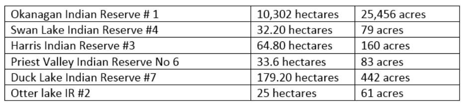
The Okanagan Indian Band reserve lands are as follows:
On average, the lands department works with the Department of Indigenous Affairs Canada (DISC) to register documents related to OKIB reserve lands, in the neighbourhood of 330 instruments per year being an average of 1.3 per day. The due diligence related to registering instruments in the Indian Land Registry can be labour intensive and depending on the complexity can take time to complete.
To better understand how Land and Housing works on OKIB Lands, read the short overview below.
View the document here: Understanding Land and Housing Opportunities on OKIB Lands (PDF/Separate Link)
The Lands Department has created this step by process document to Members better understand the Utility Service Installation process.
View the document here: Step by Step Process for Utility Service Installation (PDF/Separate Link)
The Lands Department has created this step by process document for Members to better understand the Locatee leasing process.
View the document here: Step by Step Process for Locatee Leasing (PDF/Separate Link)
Leasing, Permits, and Rights-of-Way Administration
Purpose:
To support the lawful authorization of land use under the Indian Act through leases, permits, and rights-of-way.
Details:
The step-by-step process for locatee leasing is available on the OKIB Lands website under “Locatee Leasing Process.”
Services include:
Locatee lease application processing
Permits for residential, agricultural, and commercial uses
Rights-of-way for access or utilities
Coordinating required ISC documentation
Eligibility:
OKIB Members, approved development proponents and OKIB departments
Hours: Monday–Friday, 8:00 AM–4:30 PM
Key Contact: Randy Marchand or Brittany Caron
OKIB Lands Survey process can be found at Land Survey Process Of OKIB Lands. (PDF/Separate Link)
Additions To Reserve (ATR)
Beau Park
As part of the Boundary Specific Claim settlement, OKIB and Canada have been working on the additions to reserve related to the Beau Park fee-simple properties. To date the following efforts in relation to this ATR have been completed:
Environmental Site Assessment
Re-survey of the lands
Consultation obligations with other First Nations, local governments and the Province of BC
Duck Lake CN Rail
In 1877, the Joint Indian Reserve Commission allotted Duck Lake Indian Reserve No. 7 (the “Reserve”) to OKIB. In contrast with the Commonage Reserve, which was also allotted by the JIRC, the Duck Lake Reserve was later confirmed by the McKenna McBride Commission and by Order in Council 10361 in 1938. In about 1912, the provincial legislature passed a law authorizing Canadian Northern Pacific Railway Company (“CNPR”) to build a railway between Vernon and Kelowna known as the Kelowna Line. In the same year, the federal government passed an order in council authorizing the sale of a right-of-way of 17.56 acres through the Reserve to CNPR (the “Duck Lake Rail Corridor Lands”). In 1926, the federal government transferred the Duck Lake Rail Corridor Lands to CNPR by letters patent.
In about 1956, CNPR was amalgamated with CN Rail. In 2013, CN Rail discontinued its use of the Kelowna Line. In 2014, CN Rail sold the right of way lands for the Kelowna Line except for the Duck Lake Rail Corridor Lands to the City of Kelowna. Under the terms of the sale, CN Rail was required to remove the railway infrastructure from the lands. The City of Kelowna and other local jurisdictions formed an Interjurisdictional Development Team (the “IDT”) to oversee the creation of a recreational trail along the former Kelowna Line rail corridor. With respect to the Duck Lake Rail Corridor Lands, CN Rail has indicated that it is prepared to return the lands to Canada in order that they can be restored to the Reserve.
Efforts to finalize the ATR continue.
Purpose:
To coordinate environmental responsibilities related to land use and development on OKIB reserves.
Services include:
Providing documentation and information to ISC for environmental reviews
Supporting best practices for land and environmental stewardship
Coordinating environmental responsibilities tied to land files
Maintaining ongoing environmental initiatives within the Lands Department
Additional information:
Follow this link to read about our ongoing Environmental Initiatives. (PDF/Separate Link)
Between 1943 and 1990, the Department of National Defence (DND) conducted military training activity that included live-firing of explosive ordnance (such as artillery and mortars) on two ranges located partly within Okanagan Indian Reserve No. 1, the Goose Lake Range and the Glenemma Range.
The permits issued by OKIB authorizing DND to use the reserve. Currently, an unknown quantity of UXO and munitions scrap remains on the reserve.
UXO poses a serious risk because it can explode if disturbed, resulting in injury or death. In certain circumstances, UXO and munitions scrap may also cause environmental contamination.
Follow this link to read about our ongoing efforts to remove UXO from the reserve.
DND has made and continues to make some efforts to clear UXO from the reserve; to that end, there is a memorandum of understanding which provides funding to support the UXO Liaison, Don Louis, to work with DND and OKIB on the survey and clearance work on Goose Lake and Glenemma Ranges.
As part of the on-going work with DND, funding is received for a Liaison Officer. The duties of the Liaison Office include:
-Ensure lines of communications are open between OKIB’s and DND Project Manager
-Communicate the DND’s project requirements to the OKIB’s authorities
-Assist with coordinating visits, meetings and presentations between the OKIB and DND and the Department of Construction Canada (DCC)
-Ensure that the Contractor is aware of the OKIB’s operations or activities that may impact the work of either party
-Provide all notices to, and coordinate access with, potentially affected OKIB members prior to commencement of site work
-Conduct visits during site work by DND’s Contractors to review their progress
-Meet with DND\DCC staff and accompany these individuals during visits to the OKIB
-Report any concerns or issues to the OKIB and the DND Project Manager
-Maintain regular communication with DND
-Participate in the dangers of UXO awareness program, which included the OKIB School, School district 22, OKIB community events, and neighboring community events
To date, 11 Band members have also been sponsored by DND to take the Texas A&M Engineering Extension Service’s UXO Technician I course thereby building capacity in this arena in the community.
FAQ
Because of UXO’s you must contact Don Louis at the Public Works and Housing Department at 250-542-3444 for permission to go to Goose Lake.